Historical Photographs: Buildings, Grounds, and Views
Pages
-

-
Aerial view of South Spencer Residence Hall
-
Aerial view of South and North Spencer Residence Halls, with people walking College Avenue in front to the building around 1920. The Spencer Dining Hall and kitchen sits behind South Spencer Residence Hall, the roof of the Students Building is visible in the foreground, and the Walker Bridge can be seen in the lower right.
-

-
Aerial view of campus
-
Aerial view of campus showing Alumni House, Faculty Center, Elliott University Center, Jackson Library, dining halls, Forney Building, Foust Building, and the Quadrangle residence halls in distance.
-
-
Aerial view of campus
-
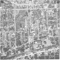
Aerial view of the University of North Carolina at Greensboro campus in 1975. The date stamped in top left corner reads "Mar 21 1975". The whole campus is pictured. Jackson Library is shown in the center with the Dining Halls Complex above it, West Lee Street is running horizontally along the bottom and West Friendly is running horizontally along the top of the photograph.
-

-
Aerial view of campus
-
Aerial view of campus and surroundings, looking southeast, circa 2000. Music Building is lower left, the Quadrangle is in the center and the construction of the Sullivan Science Building can be seen in the upper left.
-

-
Aerial view of campus
-
Aerial view of the North Carolina College for Women (NCCW) campus, with Spring Garden Street running vertically on the right and College Avenue horizontally center. Photo taken after the West Wing of Curry Building (center, far right) and the Auditorium (top right) were built in 1927, but before the first Home Economics building was built in 1928.
-

-
Aerial view of campus
-
Aerial view of campus after Old Guilford was demolished in 1935. In the upper left hand corner the Steam Plant and Curry Building (Spring Garden Street) can be seen and in the upper left is the Quadrangle. Photo by Frank Turgson, Jr.
-

-
Aerial view of campus
-
Aerial view of campus after Old Guilford was demolished in 1935. Spring Garden Street runs diagonally on the left; Walker Avenue diagonal on the right. In the upper right hand corner is the Quadrangle along with the Dining Halls Complex and Spencer residence hall. Photo by Frank Turgson, Jr.
-

-
Aerial view of campus
-
Aerial view of campus, looking down College Avenue (center), in 1947. The Foust Building and Carnegie Library (now the Forney Building) can be seen in the center.
-

-
Aerial view of campus
-
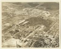
Aerial view of campus looking down Walker Avenue in 1926 or 1927. Photo taken after old Curry Building burned in March 1926, but before Mary Foust residence Hall erected in 1927. Prominent are the six residential halls built in 1922 around the quad and the tennis courts behind them as well as the Dining Halls.
-
-
Aerial view of campus
-
View of campus looking down College Avenue from the air in 1926 or 1927. Photo taken after old Curry Building burned in March 1926, but before Mary Foust residence Hall erected in 1927. In the center of the photo is Spencer Hall and the Dining Hall complex.
-

-
Aerial view of campus
-
Aerial view of campus between 1941 and 1948. The lake (top right) was completed in 1941 and then drained in 1954. In the center is the Dining Halls Complex and to the left of that is the Quadrangle.
-
-
Aerial view of campus
-
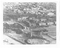
Aerial view of campus looking down College Avenue in January 1952. The Student Union (now Elliott University Center) under construction and the library, which had opened in 1950, are in the center. In the foreground are the laundry and steam plant, and the freshman quadrangle is upper left.
-
-
Aerial view of campus
-
Aerial view of campus taken between 1960 and 1965. Moore and Strong residence halls, which opened in 1960, are center right.
-

-
Aerial view of campus
-
Aerial view of campus from the south in August 1971. Lee Street runs horizontally across the bottom. The Foust Building, Curry Building (Spring Garden Street) and Steam Plant are all pictured in the center.
-

-
Aerial view of campus
-
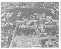
Aerial view of northwest part of campus taken November 1971. In the foreground are the Elliott Student Union, Jackson Library, and Spencer Hall. The Quadrangle and golf course are in the upper right.
-

-
Aerial view of campus
-
View of campus from overhead, looking straight down, with Jackson Library in the center. The photograph was taken March, 21 1975.
-
-
Aerial view of campus
-
Aerial photo of campus taken circa 1982, looking west towards Spencer Hall, Jackson Library (with tower), and the Bryan Building, which had opened in 1980. In the center of the photograph is the Moore building.
-

-
Aerial view of campus
-
Aerial view of campus from Tate Street, looking up Walker Avenue, in August 1995. In the bottom left is the Brown Building, with the Stone Building center and the Jackson Library behind it top center.
Pages